Mount Rogers
Virginia
July 2011 & July 2014
We’re enjoying the summit of Mount Rogers, the high point of Virginia. Which means that after hiking so many hours to gain 1500 feet of elevation, we’re doing nothing in particular, just being here. Lisa does a little exploring of the high woods in our vicinity while I absentmindedly lean on the large, conveniently placed rock, eating part of my sandwich, looking around at the arboreal abundance.
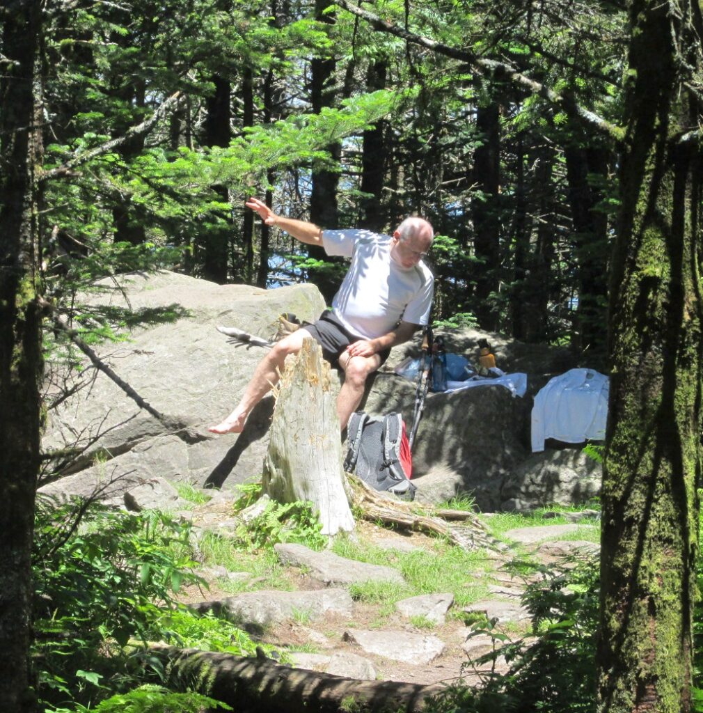
What ho? About sixty feet beyond, through the dense trees, there is another boulder and… Wait a minute. It looks like its top is higher than this one. Really? Could that rock actually be taller than this one? Or is it an illusion, like sometimes happens when we have no good reference point. And thus begins a complicated and surprising revelation concerning the high point of Virginia.
First, about the markers, or benchmarks. These are the brass, bronze or aluminum disks that are placed in very specific locations by any of several government agencies for the purpose of knowing exactly where these very specific locations are. This information is used for surveying, mapping, navigation, determining flood risk, ecosystem management and GPS reference points. Geek heaven, baby!
The markers are stamped with various words, numbers and symbols, such as the name of the agency that placed the marker, the date the marker was located, sometimes the coordinates or altitude, the initials of the fieldman who placed the marker, and often it is printed with warnings not to mess with it under penalty of punishment too monstrous to imagine. Actually if they catch you defacing or attempting to steal the marker (unlikely but possible) they slap you with a $500 fine.
Some of these markers, impressed with a triangle in the center, are designated “main stations,” indicating a precise point. Other types of markers include “reference marks.” These are stamped with an arrow pointing to the main station. And still others have various stampings that indicate other scientifically important information.
For the longest time, I assumed that the main station was placed at the highest point in the area. It turns out that it ain’t necessarily so.
As I munch on my sandwich, leaning on the rock that has the main station benchmark embedded within, the rock we all assume is the high point, I can’t help but glance sideways at that other natural object which, doggone it, looks higher. Every high pointer I’ve ever conversed with knows that this rock is the winner, the medalist, the champion. But my senses earnestly insist otherwise.
Another hiker comes around the corner on the trail and I ask him his opinion. About the sixty-feet-distant rock he says, “Looks higher to me.” That, from a stranger, a random high point passerby, is all the convincing I need.
No it isn’t.
Once home, I endeavor to get the real poop. I first contact the Jefferson National Forest. I reach Maryann on the telephone and it takes no time whatsoever for her to plead ignorance. She refers me to Grayson Highlands State Park. Alice at Grayson knows even less.
Next I try the United States Geological Survey since they place so many of these metal markers. I send an email to the USGS and in response, Cheryl in Science Information Services forwards an NGS Data Sheet to me. And thus begins my schooling.
insight #1A
The United States Geological Survey (USGS) is the largest water, earth, and biological science and civilian mapping agency. The National Geodetic Survey (NGS) provides the official framework for all positioning activities, which includes latitude, longitude, elevation and shoreline information.
insight #1B
For the life of me, I can’t tell the difference between these two agencies, the United States Geological Survey and the National Geodetic Survey. Fortunately I don’t have to.
insight #2
An NGS Data Sheet has more information than you could ever not need to know. I can get my geek on from time to time but jeez, try as I might, certain disciplines just elude me. To wit…
The geopotential number equals the dynamic height multiplied by the normal gravity at the reference latitude: C = H(dynamic) * gamma(ref).
Did you know that? I’m sure it means something to somebody somewhere. I’m sure that somebody is not me.
Frankly, I am at a bit of a loss. NGS language looks like Greek, which it originally was, and also bears a resemblance to lorem ipsum. To me, the NGS Data Sheet is basically five pages of lorem ipsum, small print.
Lorem ipsum? When examining the layout of a document, readable text can be distracting, so lorem ipsum was invented. It is dummy text, copy that has the form of real words, sentences and paragraphs but with no meaning. (Reminds me of some of the statements my students make.) To wit…
Lorem ipsum dolor sit amet, consectetur adipiscing elit. Ut a luctus purus. Donec eget arcu ac dolor dignissim fermentum. Pellentesque sed felis convallis, porttitor justo quis, scelerisque arcu.
In fact, the NGS Data Sheet looks more like lorem ipsum than lorem ipsum. It is an extraordinary exposition of incomprehensible symbols and figures. At least the data is arranged in columns and it contains explanations too. But wait. The explanations are even more confounding than the data. I’m generally not a dumb person but trying to make my way through the columns and lists of numbers and abbreviations makes me feel like I have lug nuts rattling in my hubcaps.
In addition to the Data Sheet, Cheryl from the USGS helpfully forwards my inquiry to John, State Geodetic Surveys Engineer at the Virginia Department of Transportation. John sends me the same NGS Data Sheet but he has highlighted certain passages. The highlighting, I’m sure, is intended to enhance my comprehension of this report. I print it out on paper and find that these highlights are very pretty if you hold them up to the light of a three quarter moon. I also come to a surprise understanding of the usefulness of this report; Three pages performed perfectly in catching my cat throwing up so I didn’t have to mop the floor.
John and I email back and forth. Our conclusions follow.
insight #3
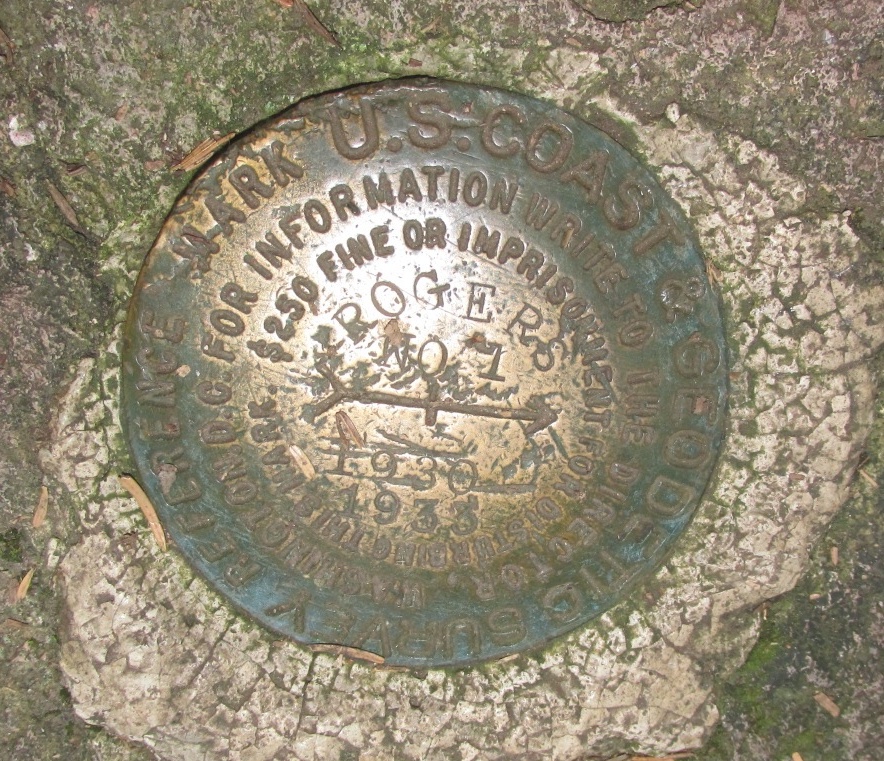
The survey markers on top of Mount Rogers are not USGS markers but rather they are United States Coast and Geodetic Survey (USC&GS) markers.
insight #4
The United States Coast and Geodetic Survey is the same agency as the National Geodetic Survey…
USC&GS = NGS
…but at this point, this no longer captures my interest. But I still want to know about the high point.
John and I talk about where the “official” high point might be, as…
insight #5
…the placing of a marker that does not have altitude stamped on it is a latitude and longitude thingy and not an altitude thingy. I ask him, “So the main station on Mount Rogers may not be the high point?”
John says, concisely, “Yep.”
I ask John, “In this case, how can I determine where the high point is?” I am secretly hoping that he interprets my question as, “How can you determine where the high point is, and then tell me?”
John answers, “You could determine the high point, but it would not be an easy task. Conventional survey methods would be the proper way to go about it, but that could be an expensive undertaking.”
Maybe I can simplify this task. I ask John if, rather than going through the entire expensive undertaking rigmarole, there might be a simpler way to determine which of the two rocks is the higher one. John says, “Yep.”
insight #6
“Using a clinometer is probably the easiest way to determine which is higher.” I believe John when he tells this to me. Life would be so much more expedient if I were to have the foggiest idea what a clinometer is. I check and find that…
insight #7
I can purchase a relatively accurate clinometer for about a hundred fifty bucks. I’m not sure, but I think that this is not the kind of thing you can take out of your pocket at the high point and read how many feet high you are. You’ve got to have a reference point, clear sighting and clinometer knowledge, and trust me, this is way too much mishigas to get into. Now or ever. I shouldn’t say “ever.” Perhaps in another lifetime I will become a surveyor or an engineer and possess my own clinometer.
Then John tells me something very disturbing as we examine the cursed Data Sheet together.
insight #8
The NGS Data Sheet reveals that the highest point of Virginia is 65 feet south of the main station: that rock there in the distance. This means, simply, that since that marker was first placed in 1930, and recovered (their word for “verified”) in 1934, 1991, 1997 and 2005, everyone who has celebrated reaching the high point of Virginia at this rock with the main station, the one that is obviously the high point, has not actually reached the high point of Virginia at all.
Disconcerting at best. I try a whole ‘nother approach. Instead of relying on surveyors or engineers who spend their time in an office, I choose someone who has actually visited the high point. I call the Appalachian Trail Conservancy. I talk with Kathryn who knows just what the summit clearing looks like. She knows because she’s been there. And, like all the rest of us, she’s always assumed that the high point is the rock with the triangle marker. When I tell her it isn’t, she makes several suggestions of experts I might contact to continue my inquiry, all of whom I have already contacted.
As we are winding up our conversation, Kathryn expresses her hope that I “…get to the bottom of this.” Ha! The bottom! She’s quite the cutup, isn’t she.
I now have one more option, one more place to turn. I want to get the information right from the horse’s mouth. Or the pony’s mouth. Remember that Greyson Highlands has ponies, not horses. I call the agency that actually placed the marker, the NGS, the National Geodetic Survey, which, as I learned back in insight #4 is the same agency as the USC&GS. I mean, it is printed right on the marker…
U. S. COAST & GEODETIC SURVEY REFERENCE MARK
…on top of Mount Rogers.
I have an excellent conversation with Simon. For twenty-five minutes, we read the Data Sheet together and he explains what it all means. And Simon confirms an amazing thing…
insight #9
The NGS Survey Data Sheet lists the boulder with the main station at 5711 feet. The NGS Survey Data Sheet lists the high point at 5729 feet.
So, yeah. Pretty much everyone who thinks she or he has been to the high point of Virginia, has not been! Soaring summits, Batman!
If word of this gets out, I stand the distinct possibility of getting lynched.
If Lisa and I ever go back to Greyson Highlands and the high point, and we would love to do that given how beautiful this place is, we will bushwhack the hell out of that summit to see if we can get ourselves a better perspective, to see if my second boulder is where the land rises another 18 feet, which would then really be the real high point. We’ll get to the bottom of this!